

|
|
|
#1
 09-25-2015, 07:08 PM
|
||||
|
||||
|
The default level of the MP is the medium level with 10,000 to 50,000 personnel. Given a few assumptions: 1), each team averages six members, 2), the contiguous states are about 3,000,000 square miles of land area, and 3), PB has about 600 personnel and PB2 has about 400 personnel we can determine an average area per team. Starting with the minimum of 10,000 MP personnel, we can make this determination.
10,000 1,000 (PB & PB2) = 9,000 team personnel 9,000 / 6 = 1,500 facilities, boltholes, bases 3,000,000 / 1,500 = 2,000 square miles per team Square root of 2,000 = 44.721 miles Each square is 44 miles by 44 miles. Each square has a six-person team assigned to it. The grid does not conform to the map due to the type of projection. The grid shown has 420 squares or teams (2,520 personnel) and represents 28% of the total number of MP teams. Now, let us change the size from 10,000 members to 50,000 members where PB has 3,000 and PB2 has 2,000 personnel respectively. In this version each square has 30 MP personnel (15,120 total for the area presented). Now, the question is "How big is your Morrow Project?" 
|
|
#2
09-25-2015, 07:43 PM
|
||||
|
||||
|
There are reasons areas are populated (water, travel routes, temperature, fertile land, etc). There are also reasons to avoid areas that are massively populated now.
My personal thought is that you should base the projects personnel distribution on the when US population distribution flipped from rural to urban (for my calculations i used 1900). This actually predates the flip, but given some areas that were rural then, are urban now this pushes a few more assets away from strikes. This allows for coverage of areas where significant people lived without an urban infrastructure, while allowing some teams to be close enough urban centers to work on recovering materials from the suburban rings. That being said the North East is still a nightmare and I keep proportionally fewer teams in that area. I think New Jersey only had 2 teams as I could only find 2 locations more than 35 miles from a strike.
|
|
#3
09-25-2015, 09:59 PM
|
||||
|
||||
|
There are five megaregions in US that skew the placement of MP teams. They are Northeast, Florida, Southern California, Great Lakes, and the Texas Triangle. There is very little area untouched by the direct effects of the war in those region and I think that the MP would understand that and not waste personnel and teams in those areas. Too much risk of their destruction. This means that a 6 person team will have an even smaller area than a straight 3,000,000 square miles served by 1,500 boltholes and bases example I posted above.
|
|
#4
09-27-2015, 10:36 AM
|
|||
|
|||
|
The number of people in the Project is simply a multiplier to the distribution itself, and the distribution should be an attempt to place teams where they can survive the war and then provide the most immediate help to people at the time they are awakened. The first factor means moving teams out of suspected targets, the second means anticipating where survivors will be living 5 years (or whenever) after the war and placing teams in proportion.
So obviously there should not be any teams IN major cities or military bases or the such, and probably not any all that close to them, either - you have to account for a certain amount of error in missile targeting! But it is reasonable (to me, at least) that people will move the least distance they need in order to find a new place they can survive, so communities and regions surrounding those targets are most likely to grow in population while more isolated communities remain static. This would suggest rings of Teams around major metropolitan areas, decreasing in frequency out into rural areas. Another issue is population density - a thousand people all clustered in one area are a lot easier to help than a thousand people spread over a thousand square miles! If we call the population density of any given area "D" and the population density of the US "D0" (currently around 85 / sq mi) then as a first order approximation you could scale the distribution by sqrt(D0 / D), to reflect that teams in less dense areas will spend more time travelling. This would mean that Florida, with D0/D ~= 1/4 would have half the Project personnel (by population) than the average, while Idaho, with D0/D ~= 4 would have twice the personnel (by population) compared to the average.
|
|
#5
09-27-2015, 11:07 AM
|
||||
|
||||
|
Well their are limitations to this........ population density, civilian infrastructure, government land, bodies of water, flood plains, mountainous terrain.
That should significantly reduce the overall terrain.
|
|
#6
09-27-2015, 12:02 PM
|
||||
|
||||
|
As I said before I distributed assets on 1900 population patterns.
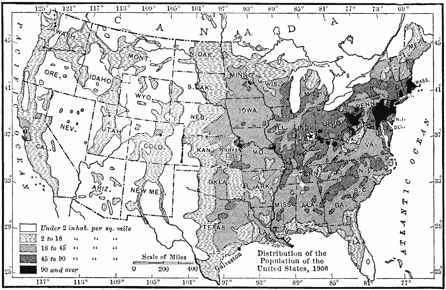 This maps shows areas that were not generally populated without more advanced technology. Breaking down the regions I would adjust team placement for the following. Pop per sq mile
These are of course generalizations. The West Coast and Florida would have had significant population growth. The overall strength of the Midwest particularly the 18-45 range can be seen though.
|
|
#7
09-27-2015, 01:14 PM
|
||||
|
||||
|
Here is a picture that shows federal lands in the US:
The article states that 28% of US land is federally owned which includes Alaska. If we assume that 1/3 of the land is unsuitable (mountains, federally owned, flood plain, etc.) for emplacement of MP teams then we would have about 2,000,000 square miles of area for the 1,500 teams. Each team now has 1333 square miles of area or about 36 miles by 36 miles. In the grid below the same general region depicted in a previous post is shown with a grid of 36 miles by 36 miles square. The red squares, each 576 square miles in area, are placed where some of the major targeted cities are located. Each green square on the grid has a six man MP team assigned to it. Note that the density is greater. So what is your minimum distance from a potential target for your MP teams' bolt-holes?
|
|
#8
09-27-2015, 02:00 PM
|
||||
|
||||
|
I generally tried to keep things 60 miles from strikes for bases and 30 miles for bolt holes. I used my mapping program to pick the general area. It has the expanded strike list loaded.
This is the broken version of my mapping program that I wanted to use as a substitute for the autonav (when I say broken, it used to overlay nuclear effects, but google changed the underlying code and I have not been motivated to fix it) http://maps.juhlin.com/map_ver_0_5_002.html The default for the map is Twilight 2000 strikes, so go to the strikes tab and click "Manage" and change the data source to "Morrow Project Expanded" Everything beyond the strike overlay should work. So you can use the tool to find local oil fields, chemical plants, power plants, hospitals, schools, etc. Click each of the tabs and then manage and you can see what the options are. If there is interest and it would be helpful I can start working on this again. When things got crappy on the T2k side of the forum I quit, but now that things are hopping and pretty pleasant on this side of the house, I could see myself working on it again.
|
|
#10
05-15-2016, 12:16 PM
|
||||
|
||||
|
Little thought......... Wouldn't Recon be located more rural; while the MARS would be located closer to major urban centers? Closer being relative.
Science, would be anywhere depending upon their specific mission. I also believe that Science teams would have relatively specific missions, not just "look and see". Probably surveying fallout patterns, water quality, and assisting medical with post Nuke epidemiology.
|
|
#11
05-16-2016, 02:03 PM
|
|||
|
|||
|
IMO, the game takes a "shotgun" approach to the team placement. I have always felt that the Project would place combined groups in key locations, seems to be a more realistic approach.
__________________
The reason that the American Army does so well in wartime, is that war is chaos, and the American Army practices chaos on a daily basis.
|
|
#12
05-16-2016, 06:58 PM
|
||||
|
||||
|
Based upon the module "Final Watch" I have created a West Tennessee Combined Group (WTCG) which includes the western part of Kentucky and northern Mississippi. The group's responsibility covers about the same area and population as the Seattle Group. There are four "fixed" installations, agricultural, medical, power and communications (noted in the list with red stars). As presented in "Final Watch" the communications installation is unmanned and may be placed in an area already occupied by a team (excluding the other "fixed" locations). The teams associated with the other "fixed" location may not abandon their installation except in dire situations (as presented in "Fall Back"). The exercise is to distribute the teams in the permitted squares on the map (using a paint program or such), post it to the thread with your reasons for the choices made. Remember that the Project was to awaken five years post war. Reference the rulebook for specified targets shown on the map.
I used S0 for Science and Support. Use the code Sp for the Support Team. Last edited by RandyT0001; 05-17-2016 at 03:57 PM. Reason: Addition and Correction
|
|
#13
05-16-2016, 07:33 PM
|
||||
|
||||
|
Quote:
 Yes, quite lovely. Yes, please fix the overlays. Yes, quite lovely. Yes, please fix the overlays. A few minor quibbles: some of the targets seem a bit off, Camp David's landing near Annapolis and Ft. A.P. Hill located out beyond Roanoke. Unless of course, these were the original targets with the deviation applied.
__________________
"Let's roll." Todd Beamer, aboard United Flight 93 over western Pennsylvania, September 11, 2001.
|
 |
| Currently Active Users Viewing This Thread: 1 (0 members and 1 guests) | |
|
|


 Linear Mode

