

|
|
|
#1
 09-20-2012, 10:34 PM
|
|||
|
|||
|
Hello All,
I came across a new site that lets you calculate nuking a city of your choice. It's a little different from the others out there so take a look. I dropped a little boy on San Jose City airport whic is one of my usual targets for such things. http://nuclearsecrecy.com/nukemap/ 
|
|
#2
09-20-2012, 11:20 PM
|
||||
|
||||
|
Superb! Thanks for posting this!
__________________
"We're not innovating. We're selectively imitating." June Bernstein, Acting President of the University of Arizona in Tucson, November 15, 1998.
|
|
#3
09-21-2012, 06:34 AM
|
||||
|
||||
|
I think this was posted before. But is still a great find. I like the multiple nuke option so you can see what effect multiple hits would have on a city.
__________________
************************************* Each day I encounter stupid people I keep wondering... is today when I get my first assault charge??
|
|
#5
09-21-2012, 08:44 AM
|
|||
|
|||
|
Thats how it looks on my phone, anyway. I'll have to look on a PC later.
Prob center another one on the General Dynamics tank plant in Lima, OH, too. Kill 3 birds with one big friggin stone (tank plant, refinery, chemical plant).
|
|
#6
09-21-2012, 08:48 AM
|
||||
|
||||
|
Quote:
__________________
 "It is better to be feared than loved" - Nicolo Machiavelli "It is better to be feared than loved" - Nicolo Machiavelli
|
|
#7
09-21-2012, 12:15 PM
|
||||
|
||||
|
Quote:
Maybe someone would be good enough to do us a T2k strike map based on megatonnage listed in various sources? Then a little overlay of fallout footprints? Also is the map accounting for ground versus air?
|
|
#8
09-21-2012, 01:25 PM
|
|||
|
|||
|
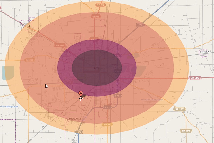
In v2/2.2, Lima wad indeed nuked, though it says that the refinery was the target. Any nuke worthy of the name, however, would be able to destroy all three targets no matter which one it was directed at.
I'll have to check my book when I get home, but if the Lima refinery deserved a nuke in v2/2.2, then the refinery in Billings should have caught one too. The refinery in Great Falls would prob have been collateral damage from the strike on Malstrom, esp if the Reds did like i did for this fun little tool and said screw the kiloton, lets go with megatonnage.
|
|
#9
09-21-2012, 02:09 PM
|
||||
|
||||
|
Quote:
__________________
************************************* Each day I encounter stupid people I keep wondering... is today when I get my first assault charge??
|
|
#10
09-21-2012, 02:29 PM
|
||||
|
||||
|
Quote:
Here is what I have for Lima. Notes:
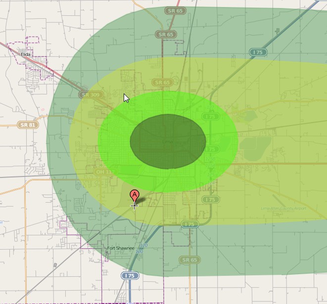      edit My notes show the refinery being here. If this is true and the Nuke was targeted here the Lima Plant would have been untouched. Can someone double check this. 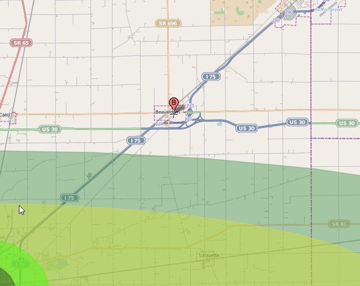 Edit 2. Cdnwolf has helped me track down where the refinery is and it looks like if it is targeted the plant is toast. http://forum.juhlin.com/showthread.p...ed=1#post57406 Last edited by kato13; 01-07-2014 at 01:18 PM.
|
|
#11
09-21-2012, 08:07 PM
|
||||
|
||||
|
Anybody know how to get archival data for November 1997 weather records? It would be interesting to see if any nukes got slightly toned down by heavy overcast/rain/snowstorms..
__________________
"Let's roll." Todd Beamer, aboard United Flight 93 over western Pennsylvania, September 11, 2001.
|
|
#12
09-21-2012, 10:45 PM
|
||||
|
||||
|
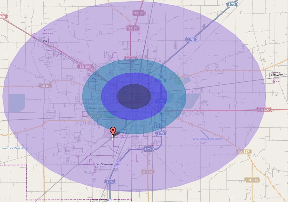
It was very interesting to see how the different yields affected Boston. The outer ring of the 100 Mt nuke reached to Worcester. I also played with the epicenter to reflect a terrorist nuke on a ship. If you can intercept a small nuke a couple of miles offshore, the detonation doesn't do much. All very interesting.
The Soviets tested their 50 megger nuke on an island in the Arctic, right? Boy, that place must have been toasted beyond imagination.
__________________
"We're not innovating. We're selectively imitating." June Bernstein, Acting President of the University of Arizona in Tucson, November 15, 1998.
|
|
#13
09-21-2012, 11:22 PM
|
||||
|
||||
|
Quote:
 *SPOILERS* Per the mini-module Lima Incident (Challenge Magazine issue 56, pages 6-9): (Page 8, middle column) "Lima was half destroyed by the blast that hit just to the southwest of the city. With most of the city in rubble and much of it uninhabitable due to radiation, the scavengers and thieves operate out of the northeast corner of the city, where the tank plant is located." The module is all about a CivGov SOG unit being sent on a secret mission to secure the tank plant following intelligence suggesting there are 30 intact M1 Abrams MBTs sitting parked there.
__________________
"It is better to be feared than loved" - Nicolo Machiavelli
|
|
#14
09-22-2012, 01:34 AM
|
|||
|
|||
|
kato, the refinery in Lima is IN Lima, not Beaverdam.
I don't know how to get the pics that others have posted to show, but I plugged the address for the tank plant and the refinery into Google maps, and it says they're 1.5 miles (2.4 kilometers) away from each other. In case anyone wants to see the pic, or post it here: General Dynamics Joint Systems Manufacturing Center: 1155 Buckeye Rd, Lima OH Husky Lima Refinery: 1150 S Metcalf Street, Lima, OH And at .8 of a mile from the tank plant, we have: Ineos USA (chemical plant) and Arcadian Ohio LP: 1900 Fort Amanda Rd
|
|
#15
09-22-2012, 01:39 AM
|
|||
|
|||
|
Quote:
|
|
#16
09-22-2012, 01:50 AM
|
||||
|
||||
|
Quote:
https://maps.google.com/maps?q=40.83...01929&t=m&z=16 I'll make the adjustment. However I agree that the Challenge article seemed to mistake northeast and southwest so I'm not sure if I should move the strike location.
|
|
#17
09-22-2012, 02:27 AM
|
|||
|
|||
|
Quote:
") I sometimes wonder if the same people named the streets in EVERY city in NW Ohio. Seems like every town that had more than two stoplights had a Street, Road, Avenue, or Boulevard named Wayne, Columbus, Franklin, Lima, Findlay, Detroit, or Marion. Findlay Road in Lima, Lima Avenue in Findlay.....ghack! Even better were county roads...the same road might be County Road 12, Township Road 18, and Marion-Gallion Road. Do our Aussie and Euro friends have nightmarish road names/systems?
|
|
#18
09-22-2012, 12:27 PM
|
||||
|
||||
|
Quote:
Since western Ohio, southern Michigan were settled about the same time (turn of the 19th century, right?) they were influenced by the current popular terms and names--Rev War generals who influenced the region (Wayne), war heroes (Marion), great statesmen (Franklin), directional roads (Detroit, the-way-to)--not just roads but towns, townships, and counties, too. Have you tried navigating in the great state of Delaware? They don't seem to use the same logic in displaying route signs and junction indicators. Luckily, it's a small state and if you get lost, you don't have to travel far from the other end to where you should have been going.
__________________
"Let's roll." Todd Beamer, aboard United Flight 93 over western Pennsylvania, September 11, 2001.
|
|
#19
09-22-2012, 03:57 PM
|
|||
|
|||
|
Quote:
|
|
#20
09-22-2012, 07:41 PM
|
|||
|
|||
|
Quote:
|
 |
| Currently Active Users Viewing This Thread: 1 (0 members and 1 guests) | |
|
|


 Linear Mode

