
 |
 |
|
#1
|
|||
|
|||
|
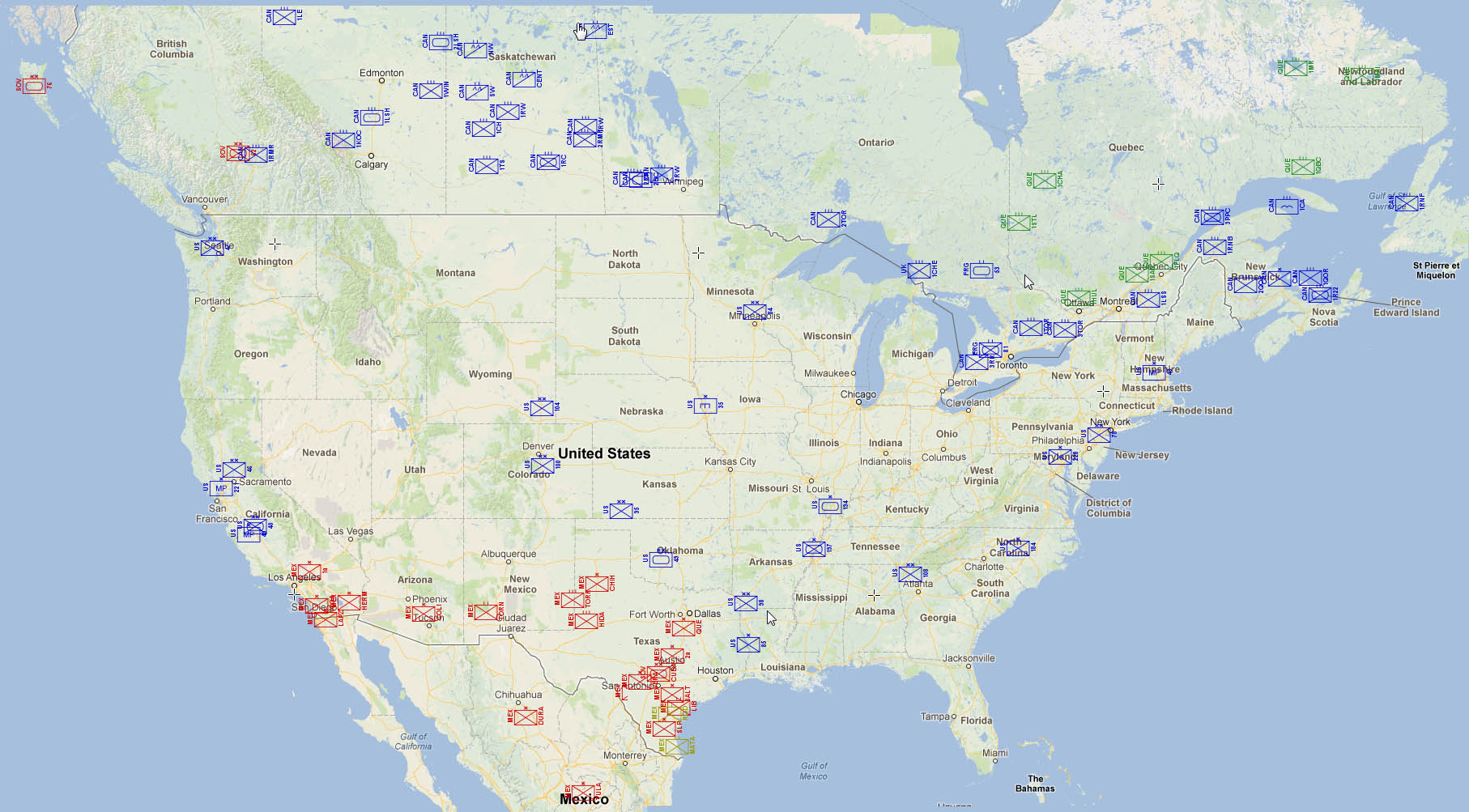
Been playing around with this, will add New America, Soviet, Canadian, French, and Mexican forces the next couple of days. May throw in some marauder units as well were notable forces are documented in canon.

|
|
#2
|
|||
|
|||
|
Forgot to add...counter symbology: 1st on bottom is thousands of men (rounded up, so 1200 men = 2), 2nd number = # of AFVs in unit. Number to the right of unit type is the unit name / number.
|
|
#3
|
|||
|
|||
|
This is great, maps really help me visualize the layout of forces.
|
|
#4
|
||||
|
||||
|
This is what I built a while back.
 Unfortunately Google maps has changed versions at least twice since I built it so I am stuck with only screen shots rather than it being interactive. |
|
#5
|
|||
|
|||
|
Quote:
One of the things I'm also trying to do as I build out the maps is use urban areas from circa 2000 for cities. There's been a lot of sprawl in a lot of urban areas in the last 30 years since T2K was published (and road building). |
|
#6
|
||||
|
||||
|
I long for an archive of the old Microsoft TeraServer map tiles. It came out around 97 or 98 and was an impressive set of map tiles. A lot of the higher zoom levels were ortho-adjusted aerial photography IIRC. I've always wanted it for historical comparisons with modern maps but it would be an amazing T2K mapping resource.
|
|
#7
|
|||
|
|||
|
I once again would like to share this excellen website: https://www.map.army/
Map.Army allows the user to facilitate so called MilX-layers to create maps that visualize tactical, operative or even strategical situations with APP-6 conform icons. Different map types can be used, such as satellite, topographic, road based or terrain oriented including Google based information such as cultural, natural or commercial landmarks. From the web based application printouts in various scales can be generated, which includes multilayer PDFs. Also, various layers can be switched off so that these maps can be presented to players in a different form that they're being used by the GM: Either by printing out only select layers or sharing one browser window, while working on or looking into another browser window.
__________________
Liber et infractus |
|
#8
|
|||
|
|||
|
Do you remember where the West German (FRG) 63th Tank Battalion comes from sourcewise? I reckon, they were going through training at Shiloh, when war broke out?
__________________
Liber et infractus |
|
#9
|
|||
|
|||
|
Quote:
In my first run on Sunday, I was mentally tired and lazy. My first attempt at showing the unit icons was just to print the APP-6 true-type font NATO icon. This lead to less than spectacular results, however, as the font glyph has a transparent background, and no color combination really shows up well on the map. I also didn't have the brain power left to figure out how to set up the rules to put all of the various unit decorations, so I ended up just creating each unit icon as an .svg file in Illustrator and using a rule to match the file to the unit name. That being said, it irked me, so I worked on it this morning:  That example is a 100% pure "programmatic" output, using a shapefile database (could just as easily be an excel spreadsheet or csv file, but I can drag and drop shapefile elements onto the map visually, and shapefiles can contain row/column data, so I tend to use shapefiles for even columnar data in cases like this). Adding a new unit is as easy as clicking on the "Add Point Feature", clicking on the map for the location, and then typing in the data:  If I want to plop the 49th on Fort Hood, I can just drag it there:  And if I don't like the v1 map style aesthetic and want a satellite view, I just change the map layer:  Same thing with zooming in and zooming out different map resolutions. QGIS makes adding / removing features with a relative minimum amount of work much easier than say, doing the same map in Google Earth, Photoshop, or Illustrator. Not crapping on Map.Army because I only took a cursory look on it, I'm just a big fan of QGIS for mapping, be it professional or amateur GIS work or RPG related play. I'm still also very obviously learning the ins and outs of it. |
|
#10
|
||||
|
||||
|
Quote:
It comes from a Challenge article on Canada. (It should be 53rd on the graphic but might be too hard to read. Anglo-German Brigade (Ontario) 1/The Royal Hampshire Regiment: 250 cavalry (Kitchener). 1/The Cheshire Regiment: 350 men (Sault Ste. Marie). 53rd Panzer Battalion: 250 men, 9 AFVs (Sudbury). 81st Panzer Grenadier Battalion (M): 300 men, 6 AFVs (Waterloo). Edit and yes they come from training in Shilo Quote:
|
|
#11
|
|||
|
|||
|
The talk of wargaming the Siege of Warsaw inspired me to create this map variant:

Last edited by castlebravo92; 11-29-2023 at 08:20 PM. |
 |
| Currently Active Users Viewing This Thread: 1 (0 members and 1 guests) | |
|
|